|
IGNACIO ESCUDERO |
|
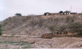
Promontorio "Cerro Mocho" Promontory Cerro Mocho" Vorgebirge Cerro Mocho |
|
IGNACIO ESCUDERO Quien
viaja por la Panamericana hacia Talara y a unos 25 kilómetros de
Sullana, puede observar claramente un cerro como si hubiera sido cortado
(ilustración). Se dice que debido a las crecidas del río Chira, los
zapotoleños tuvieron que emigrar en busca de zonas más seguras y entre
los lugares elegidos se ubicaron en lo que hoy es esta elevación
conocida como “Cerro Mocho”. Otros fueron a Ventarrones, Monte Lima,
Alto Grande. Los zapotoleños, como necesitaban materiales para construir sus chozas empezaron a sacar bloques de piedra del referido cerro hasta dejarlo bastante bajo y cortado. Cuentan los viejos residentes, que los hacendados ordenaron a los peones aplanar la cima para construir las casa haciendas en el lugar, abandonando la obra por lo difícil que era ejecutarse, para finalmente construir sus casas en la parte baja como aún pueden apreciarse aunque en estado ruinoso UBICACIÓN
GEOGRÁFICA.- El distrito de Ignacio Escudero se encuentra ubicado a la margen derecha del río Chira y a unos 35 m.s.n.m. Su ubicación geográfica, latitud sur 04º50’35’’ y longitud oeste 80º52’12’’. Dista 25 kms de la ciudad de Sullana, vía Panamericana. Tiene una extensión territorial de 306.53 kms2 y una población de 14,765 habitantes. La
capital de Ignacio Escudero es San Jacinto, pero más se le conoce como
“Cerro Mocho”. CLIMA.- Es caluroso en verano con una temperatura entre 33 y 38ºC, con lluvias irregulares. El invierno es ligeramente frío con una mínima de 20ºC |
IGNACIO ESCUDERO Who travels for the Pan-American one toward Talara, to some 25 kilometers of Sullana, he can observe a hill clearly as if it had been cut (illustration). it is said that due to the grown of the river Chira, the zapotoleños had to emigrate in search of surer areas and among the elected places they were located in what today is this well-known elevation as Cerro Mocho (“Blunt Hill”). Others went to Gales, Mount Lima, High Big. The zapotoleños, like they needed materials to build their shacks they began to take out blocks of stone of the referred hill until leaving it quite low and cut. The old residents count that the farmers ordered the peons to smooth the summit to build the house-country properties in the place, abandoning the work for the difficult thing that it was to be executed, for finally to build their houses in the low part as they can still be appreciated although in ramshackle state. GEOGRAPHICAL LOCATION. - Ignacio's Squire district is located to the right riverbank of the river Chira, to about 35 meters on the level of the sea and to 25 Km. of the city of Sullana, via Pan-American. Their geographical location, south latitude 04º50'35 ' ' and longitude west 80º52'12 ' '. The territorial extension belongs to 306.53 kms2 and a population of 14,765 habitantes. Ignacio Escudero capital is San Hyacinth, but well-known as “Cerro Mocho” CLIMATE. - It is hot in summer with a temperature between 33 and 38ºC, with irregular rains. The winter is lightly cold with a minimum of 20ºC |
IGNACIO ESCUDERO Wer reist für das Pfanne-amerikanische zu Talara, zu einigen 25 Kilometern Sullana, den er eindeutig einen Hügel beobachten kann, als ob es geschnitten worden war, (Abbildung). es wird gesagt, daß wegen das gewachsen vom Fluß Chira, die zapotoleños mußten in Suche sichererer Gebiete emigrieren, und unter den gewählten Stellen wurden sie im gefunden, was heute dieses bekannte Hochheben wie Cerro Mocho ist, (“Stumpfer Hügel”). Andere gingen zu Stürmen, Berg-Lima, Hoch Groß. Der zapotoleños, wie sie mußten Materialien ihre Hütten bauen, sie fingen an, Block von Stein des gesprochenen Hügels herauszunehmen bis das Verlassen davon ganz niedrig und Schnitt. Die alten Bewohner zählen, daß die Bauern den peons befahlen, den Gipfel zu glätten, um die Haus-Staat-Eigenschaften in der Stelle zu bauen und die Arbeit für die schwierige Sache verließen, die es ausgeführt werden würde, für schließlich ihre Häuser im niedrigen Teil zu bauen, als sie noch geschätzt werden können, obwohl in baufälligem Staat. GEOGRAPHISCHE LAGE. - Ignacio Squire Gebiet wird zum richtigen Flußufer des Flusses Chira gefunden, zu ungefähr 35 Metern auf dem Niveau des Meeres und zu 25 Km. von der Stadt von Sullana, über Pfanne-amerikanisch. Ihre geographische Lage, Süden Breite 04º50'35 ' ' und Länge West 80º52'12 ' '. Die territoriale Vergrößerung gehört zu 306.53 kms2 und einer Bevölkerung von 14,765 habitantes. Ignacio Escudero, den Kapital San Hyacinth ist, aber bekannt als “Cerro Mocho” KLIMA. - Es ist in Sommer mit einer Temperatur zwischen 33 und 38ºC, mit unregelmäßigen Regen, heiß. Der Winter ist leicht mit einem Minimum von 20ºC kalt |
|
|
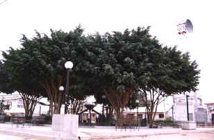
plaza de ignacio escudero Square of Ignacio Squire Quadrat von Ignacio Escudero |
|
|
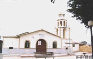
Iglesia de Ignacio Escudero Temple of Ignacio Squire Tempel von Ignacio Escudero |