MARCAVELICA
|
|
|
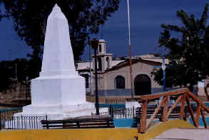
Plaza Tangarará |
|
UBICACION GEOGRAFICA-. El
distrito de Marcavelica se localiza a solo kilometro y medio al norte de
la ciudad de Sullana desde donde se llega atravezando cualquiera de sus
dos puentes. La capital del distrito es el pueblo de Marcavelica. Su latitud sur es de 04º52’39’’ y su longitud oeste 80º41’51’’. Se encuentra aproximadamente a 50 m.s.n.m. Marcavelica es un distrito estratégico en el desarrollo provincial de Sullana siendo el resultado de la convergencia de distintos componentes naturales (ubicación, superficie, recursos), económicas (zonas agrícolas, infraestructura vial) y humanos (descendencia de los tallanes). El distrito de Marcavelica posee áreas para la recreación activa y pasiva que no están debidamente explotadas. Tiene en su territorio áreas naturales protegidas como es una parte del Parque Nacional de los cerros de Amotape y el coto de caza El Angolo, que integran la importante reserva de biósfera del nor-oeste del Perú, considerados atractivos turísticos y centros para el desarrollo del turismo ecológico EXTENSION.
Tiene un área de 1,687 km2,
representando el 31% de superficie territorial provincial CLIMA.-
Tiene un clima sub-árido tropical cálido y atmósfera húmeda con
temperatura máxima de 37ºC y una mínima de 19ºC, en las partes
bajas. En la parte del Angolo el clima varía, teniendo que a más de
500 m.s.n.m. el clima es árido en la mayor parte del año. POBLACION.-
Tiene aprox. 22,452
habitantes. Electores: 11,219. |
GEOGRAPHICAL LOCATION -. The district of Marcavelica is located to single kilometer and half to the north of the city of Sullana from where you arrives crossing anyone of its two bridges. The capital of the district is the town of Marcavelica. Their south latitude is of 04º52'39'' and its longitude west 80º41'51''. It is approximately to 50 meters on the level of the sea Marcavelica is a strategic district in the provincial development of Sullana being the result of the convergence of different natural components (location, surface, resources), economic (agricultural areas, infrastructure of roads) and human (descendant of the tallanes) . El district of Marcavelica possesses areas for the active and passive recreation, but that they are not properly exploited. Has in their territory natural areas protected as it is a part of the National Park of the hills of Amotape and the hunt limit The Angolo that integrate the important reservation of biosfera of the nor-west of the Peru, considered tourist attractiveness and centers for the development of the tourism of ecology EXTENSION. Has an area of 1,687 km2, representing 31% of territorial surface of the county CLIMATE. - Has a warm tropical sub-arid climate and humid atmosphere with maximum temperature of 37ºC and a minimum of 19ºC, in the low parts. In the part of the Angolo the climate varies, having that to more than 500 meters on the level of the sea the climate is arid in most of the year. POPULATION. - Has approximately. 22,452 inhabitants. Voters: 11,219. |
GEOGRAPHISCHE LAGE-. Das Gebiet von Marcavelica wird gefunden, um Kilometer und Seite zu auszuwählen das nördlich von der Stadt von Sullana von, wo Sie ankommen und jemanden von seinen zwei Brücken überqueren. Das Kapital des Gebietes ist die Stadt von Marcavelica. Ihre Süden-Breite ist von 04º52'39 ''und seine Länge West 80º41'51''. Es ist ungefähr zu 50 Metern auf dem Niveau des Meeres Marcavelica ist ein strategisches Gebiet in der provinziellen Entwicklung von Sullana, der das Ergebnis von der Konvergenz anderer natürlicher Bestandteile ist, (Lage, tauchen Sie auf, Ressourcen), wirtschaftlich (landwirtschaftliche Gebiete, Infrastruktur von Straßen) und Mensch (Nachkomme des tallanes) . El Gebiet von Marcavelica besitzt Gebiete für den aktiven und passiven Sport, aber daß sie nicht richtig ausgebeutet werden. Hat in ihrem Territorium natürliche Gebiete, die geschützt werden, als es ein Teil vom Nationalen Park von den Hügeln von Amotape und der Jagd ist, begrenzen Sie Den Angolo, von dem das wichtige Bedenken von biosfera integriert, das noch-West vom Peru, betrachtete Tourist-Attraktivität und Zentren für die Entwicklung vom Tourismus von Ökologie VERGRÖßERUNG. Hat ein Gebiet von 1,687 km2 und stellt 31% von territorialer Oberfläche der Grafschaft dar KLIMA. - Hat ein warmes tropisches Unter-dürres Klima und feuchte Atmosphäre mit maximaler Temperatur von 37ºC und einem Minimum von 19ºC, in den niedrigen Teilen. Im Teil vom Angolo variiert das Klima und hat das zu mehr als 500 Metern auf dem Niveau des Meeres das Klima, ist im meisten des year. dürr BEVÖLKERUNG. -Hat ungefähr. 22,452 Bewohner. Wähler: 11,219. |