QUERECOTILLO
|
|
|
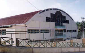
coliseo cerrado de querecotillo |
|
UBICACIÓN GEOGRÁFICA.- Querecotillo está situado a la margen derecha del río Chira, siendo capital del distrito del mismo nombre. Tiene una ubicación geográfica de latitud sur 04º50’10’’ y longitud oeste de 80º39’01’’ y una altitud aproximada de 65 m.s.n.m. Tiene un área de 270.08 kms2 y una población de 23,200 habitantes La topografía del distrito es mas bien plana con pequeños contrafuertes de la cadena de Los Andes, siendo las partes más bajas a orillas del valle, existiendo algunas quebradas como la de Hualtacal, La Margarita, Corregidor, La Chilena, etc. CLIMA.-
Es caluroso en verano, con temperaturas que oscilan entre los 30 y 37ºC., con lluvias irregulares como en todo el valle. En invierno la temperatura oscila entre 18º y 25º |
GEOGRAPHICAL LOCATION. - Querecotillo is located to the right riverbank of the river Chira, being capital of the district of the same name. He has a geographical location of south latitude 04º50'10 ' ' and longitude west of 80º39'01 ' ' and an approximate altitude of 65 m.s.n.m. Has an area of 270.08 kms2 and a population of 23,200 inhabitants CLIMA.- It is hot in summer, with temperatures that oscillate among 30 37ºC., with irregular rains as in the whole valley. In winter the temperature oscillates between 18º and 25º |
GEOGRAPHISCHE LAGE. - Querecotillo wird zum richtigen Flußufer des Flusses Chira gefunden und ist Kapital vom Gebiet des gleichen Namens. Er hat eine geographische Lage von Süden Breite 04º50'10 ' ' und Länge westlich von 80º39'01 ' ' und eine ungefähre Höhe von 65 m.s.n.m. hat ein Gebiet von 270.08 kms2 und einer Bevölkerung von 23,200 Bewohnern CLIMA.- Es ist in Sommer heiß, mit Temperaturen, die unter 30 37ºC schwingen., mit unregelmäßigen Regen als im ganzen Tal. In Winter schwingt die Temperatur zwischen 18º und 25º |