SULLANA
|
HISTORIA |
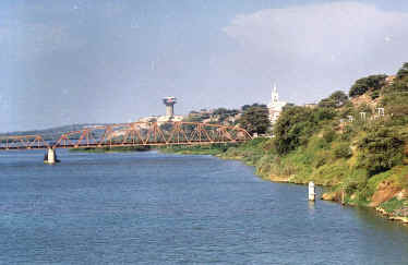 |
A orillas del río Chira Beside the river Chira Neben dem Fluß Chira |
|
|
Ciudad de Sullana City of Sullana Stadt von Sullana |

|
UBICACIÓN
GEOGRAFICA.- La ciudad de
Sullana, es la capital de la provincia de Sullana. Se ubica a 04º53’18”
de latitud sur y 80º41’07” de longitud oeste, a una altura de 60
m.s.n.m., a la margen izquierda del río Chira y situada a 39 km. Al
nor-oeste de la ciudad de Piura unida por la carretera Panamericana. EXTENSIÓN.-
El
territorio distrital tiene una extensión de 488.10 km2. Las
ciudades de Sullana Bellavista
ocupan un área de 1,757 Hás. POBLACIÓN.-
El distrito
de Sullana tiene 138,285 habitantes. CLIMA.- Su clima es
tropical, con una temperatura media de 24ºC., llegando la máxima casi
a los 35ºC. y la mínima a los 15º C. La dirección del viento es de
sur-oeste a nor-oeste, con una velocidad máxima de 36 km/hora. La
humedad relativa promedio es de 70%, aunque en el verano, por el
microclima en el valle puede llegar a 90% CARACTERÍSTICAS
GEOGRÁFICAS.- La ciudad se ha
desarrollado a lo largo del río Chira, sobre una “meseta”. La
topografía del terreno del distrito de Sullana, como características
geográficas presenta un terreno ondulado y con escaso relieve,
superficies llanas y suaves hondonadas, con lechos secos de escorrentía,
que se alternan con lomas alargadas y prominencias de formas redondeadas El
accidente topográfico más importante es el acantilado de la margen
izquierda del río Chira, donde
se ubica parte de la ciudad, entre la loma de Mambré y el puente
“Artemio García Vargas”, con una altura de 35 metros sobre el nivel
del río Las
mayores elevaciones se encuentran a lado de dicho acantilado, que de
este a oeste son: - La loma de Mambré con una altura de 82 m.s.n.m., ubicada al
costado del cementerio “San José”. Comprende un acantilado con
una altura de 12 metros en la desembocadura del canal vía o
quebrada de Cieneguillo (a espalda del cementerio), que a su vez es la
parte más baja del territorio que ocupa la ciudad -
La loma de la plaza de Armas -
Monte de la Paloma (donde está el Hospital del
Ministerio de Salud) y, - La loma de Teodomiro,
(donde está la comandancia general del E.P.) Por
otro lado existen quebradas localizadas dentro y fuera de la ciudad: - Quebrada de
Cieneguillo. -
Quebrada Cola del Alacrán. -
Quebrada de Bellavista. - El Boquerón. SISTEMA
VIAL.- Está
conformado por: - La carretera Panamericana que divide la ciudad en este
y oeste. - El canal-vía, que divide la zona en norte y sur. - El cuartel militar, que divide a los distritos de Bellavista y
Sullana VÍAS
URBANAS PRINCIPALES: -
Av. José de Lama. -
Av. Buenos Aires. -
Av. Champagnat. -
Canal vía. VÍAS
REGIONALES: Son
aquellas vías que canalizan los flujos de la ciudad de Sullana con los
principales centros de la provincia y de la región. Desde la ciudad de
Sullana se tienen las siguientes salidas: AL
NORTE: -
Marcavelica - Tumbes Marcavelica-Talara-Tumbes
por la vía Panamericana -
Marcavelica - Loja Marcavelica-Salitral- Querecotillo- Lancones-Alamor-Loja
(Ecuador) AL
SUR: -
Piura –Lima: Piura
- Chiclayo - Trujillo Chimbote
-Lima, por la vía Panamericana AL
NOR ESTE: -
El Cucho – Suyo - Ayabaca: El
Cucho – Chalaco -Las Lomas –Suyo - La Tina - Macará (Ecuador). De
Suyo hacia Paimas y
Ayabaca. AL
SUR ESTE Tambogrande-Las
Lomas-La Tina-Macará (Ecuador). De Suyo hacia
Ayabaca AL
OESTE: -
Jíbito - Paita Jíbito-Sojo-Vichayal-La
Huaca-Paita INTERdistrital
DE SULLANA A: Marcavelica: 2
Km. Salitral: 7 Km. Querecotillo: 11
Km. Lancones: 45 Km. Miguel Checa: 12
Km. Ignacio Escudero: 26 Km. Tangarará 13 Km. INTERPROVINCIAL DE SULLANA A: Piura: 39 Km. Talara: 79 Km. Paita: 60 Km Tambogrande: 46
Km. Las Lomas: 76 Km. Ayabaca: 183 Km Lima: 1,016 Km.
|
GEOGRAPHICAL LOCATION.
The city of Sullana, is the capital of the county of Sullana. It is located at 04º53'18” of south latitude and 80º41'07” of longitude west, to a height of 60 m.s.n.m., to the left riverbank of the river Chira and located 39 km. To the nor-west of the city of united Piura for the Pan-American highway. El territory of the district has an extension of 488.10 km2. The cities of Sullana Bellavista occupies an area of 1,757 Hás. The district of Sullana has a population of 138,285. Their climate is tropical, with a half temperature of 24ºC., arriving the maxim almost at the 35ºC. and the minimum one to the 15º C. The address of the wind is from south-west to nor-west, with a maximum speed of 36 km / hour. The humidity relative average is of 70%, although in the summer, for the micro climate in the valley can arrive at 90% The city has been developed along the river Chira, on a “plateau”. The topography of the land of the district of Sullana, as characteristic geographical it presents a wavy land and with scarce relief, surfaces flat and soft hollows, with dry channels of escorrentía that are alternated with lengthened hills and prominences in rounded ways. The most important topographical accident is the cliff of the left riverbank of the river Chira, where part of the city is located, between the hill of Mambré and the bridge “Artemio García Vargas”, with a height 35 meters on the level of the river. The biggest elevations are to side of this cliff that of this to west are: -
The hill of the square of Weapons -
The hill of Teodomiro, (where the general command of the E.P is.) on the other hand gulches located inside exist and outside of the city: - Gulch of Bellavista. SISTEMA VIAL. - It is conformed for: - The Pan-American highway
that it divides the city in this and west. -
The military barracks, - Av. José de Lama. - - Av. Buenos Aires. REGIONAL VÍAS: They are those roads that channel the flows of the city of Sullana with the main centers of the county and of the region. From the city of Sullana the following NORTH salidas: AL is had: To the NORTH: - Marcavelica - you Knock down - PIURA –LIMA:PIURA - CHICLAYO - TRUJILLO AL NOR THIS: - The Cucho–His - Ayabaca: AL SOUTH THIS - Tambogrande–Macará: Tambogrande-Las Lomas Tina-Macará (Ecuador). Of His toward Ayabaca AL WEST:
|
GEOGRAPHISCHE LAGE.-
-
Der Hügel vom Quadrat von Waffen -Der Hügel von Teodomiro, (, wo der allgemeine Befehl vom E.P ist.) andererseits existieren Bergschluchten, die innen gefunden werden, und außerhalb der Stadt: SISTEMA VIAL. - NORDEN: AL gehabt: Marcavelica-Loja TRUJILLO -Der Cucho–His-Ayabaca: MACARÁ: Vichayal-der Huaca-Paita |